🔥 🔥 🔥 🔥 🔥 <br />from the ashes<br />of shapefiles<br /> 🔥 🔥 🔥 🔥 🔥 /// # Zanesville, OH ///  /// ## Demographics | | | |---|---| | Population | 25,376 | | Median Age | 37 | | Median HH Income | $28,258 | | Poverty | 29.3% | /// ## Historical Context - Esri Licensing Since 2000 - Two GIS Users - City Engineer - CAD Technician /// ## Legacy Setup - ArcMap & ArcPad - Shapefiles & Rasters - Internal Network Share /// ## 20 Years of Data - ~300 Shapefiles - 20GB Vector Data - 100s of MXDs - **100s of .lock Files** /// 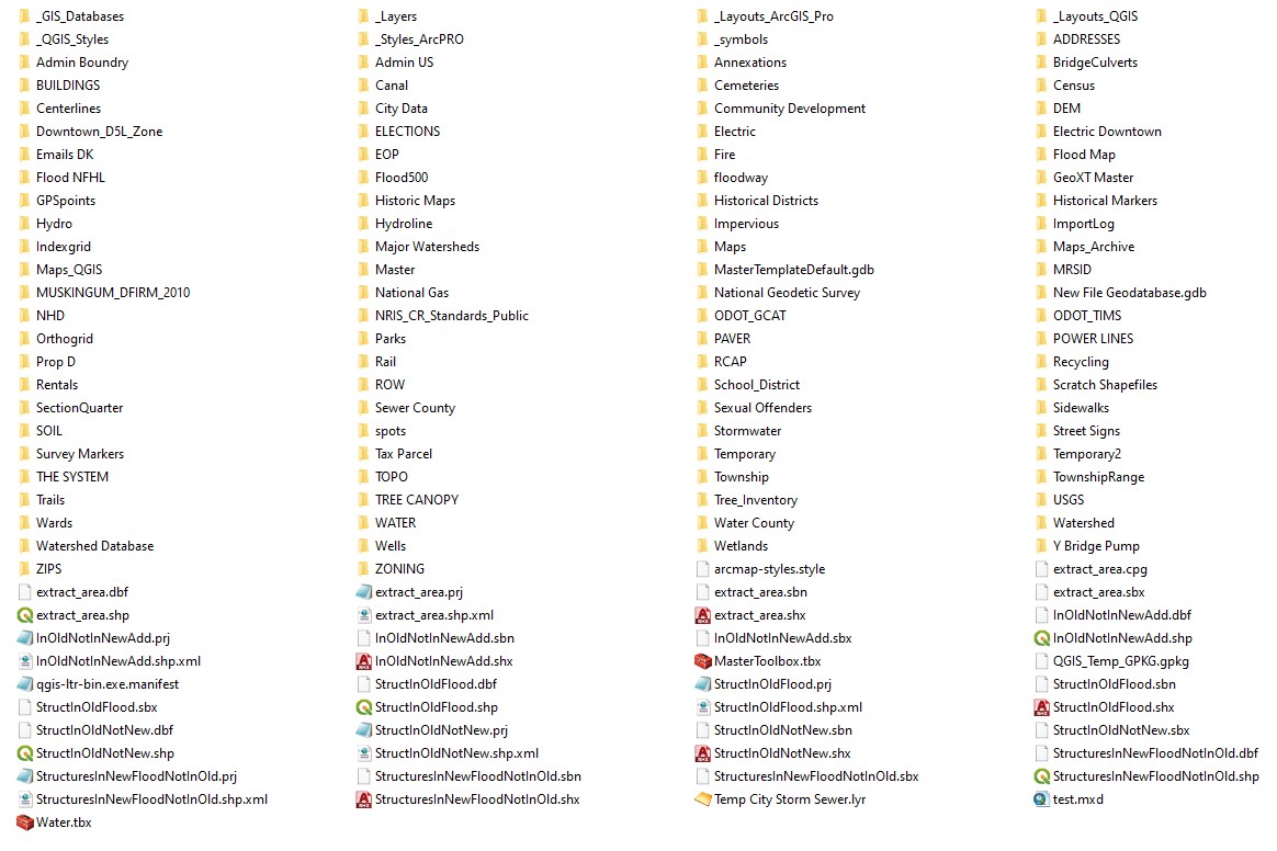 /// <img src="https://media.giphy.com/media/XWJhb2RI0qjnO/giphy.gif"> /// <img src="https://media.giphy.com/media/pylpD8AoQCf3CQ1oO2/giphy.gif"> /// ❗❗❗❗❗❗ <br> File Geodatabases <br> ❗❗❗❗❗❗ /// ## FGDB Benefits - Domains - Feature Datasets - Geometric Networks /// # BUT... /// <img src="https://media.giphy.com/media/3o7buhiXgPU8GmQp4A/giphy.gif"> /// ## FGDB Issues - Local FGDB Not Backed Up - S l o w Network - **rANd0m Data Loss** /// ## Esri Support > FGDB served over a network share is NOT a supported setup /// ## Solution RDMS Database on Enterprise /// ### 😟 🙍 🥺 ### No Esri Enterprise /// ### SQL Server Express ### ✨ 😺 😃 ✨ /// ### Get Glowing Review From SQL Exp User /// ## Repurposed Server - Windows Server 2012 - 8 Cores, 16GB RAM /// ### Setup SQL Server Express, Permissions & Import Data /// # Everything was working great... ///  /// ## SQL Express Issues - Slow to Select/Start Editing - Three Connection Limit - 4GB Mem Limit ///  /// ~~Shapefiles~~ ~~FGDB~~ ~~SQL Server Express~~ /// ### 🧐 Alternatives 🤔 ///  /// <img src="https://cdn.glitch.com/08811e29-66d4-4db8-9f1b-57c0d4d342fe%2Fqgis_azure.png?v=1596030658715"> /// # Overview /// ## Database PostgreSQL v11 & PostGIS v3.0 /// ## PostgreSQL v11 Postgres First Released in 1996 View-Only Support in ArcMap & ArcPro /// # Desktop /// ## QGIS 3.1 Editing & Print Maps /// ## ArcGIS Pro Editing of AGOL & Print Maps /// ## ArcMap Viewer for Legacy Users (2) /// # Web /// ## Database to Web Postgres -> <br> NodeJS -> <br> GeoJSON -> <br> Vector Tiles /// ## Mapbox GL JS - Internal Applications - Public Map Viewer - **Simple Print Maps** /// <img src="./web-print-map-ii.jpg" width="80%"> /// ## ArcGIS Online - Water Utility Data - Collector - Dashboards - WebAppBuilder - Story Maps /// # Benefits /// ## Postgres/QGIS Benefits - Database Views - Geometry Checks - QGIS Projects stored in DB - **Open Licensing** - QGIS Plugins /// # Issues /// ## Missing Features - Editor Tracking - Editing in ArcMap or Pro - Esri Transformations - Geometry Fields - Postgres != ArcGIS Online /// ## Enterprise? /// ## Issues with Upgrading - Administration Changes - Benefits Difficult to Communicate - COVID-19 & Budget Cuts /// # Future Direction /// ## Live Web Services > [pg_featureserv](https://311.coz.org/api/v1/feature-server/collections.html) > [pg_tileserv](https://311.coz.org/api/v1/vector-tiles/public.adm_mus_parcels.html) ///  /// ## Shapfiles > Still used as the default cross-platform data format. /// Contact Info ## Malcolm Meyer ### [@getbounds](https://twitter.com/getbounds)